

It reads the site on its own
One GPS coordinate, one phone video, one photo of a living room. We start from the current state, with no prior drawings and no BIM.
SPECIAL & SPATIAL INTELLIGENCE
GIPTER uses drones and AI to watch over structures people cannot easily climb, and 3D spatial technology to turn the spaces people live in into data. Physical AI that reads a site's shape on its own is the shared root of every product.
SPECIAL & SPATIAL INTELLIGENCE
Gipter Inspect · TetraRe · AInterior
Who we are
Building on photogrammetry, remote sensing and 3D reconstruction, GIPTER develops technology that reads real space with sensors and interprets it with AI. On one side we look for risk in built structures; on the other we picture change in the places people live. Both start from the same question — what condition is this space in right now?
For structures people cannot easily climb, we send a drone instead. Give it a single GPS coordinate and the aircraft works out the shape on its own, combining optical, thermal and LiDAR sensing as conditions demand to find damage member by member. No drawings, no prior plan — it starts right there in the field.
The spaces people live in every day are reconstructed in 3D from a single smartphone. We separate structure from belongings, bring back the walls and floors that were hidden, and build the space as it stands before anything changes. New interiors are tested on top of that.
What joins the two directions is the same engine for reading and interpreting space. On a foundation of measurement built through photogrammetry and remote sensing, we layer autonomous flight control, multi-sensor fusion AI and video-based 3D reconstruction.
SPECIAL & SPATIAL INTELLIGENCE A special space, and the intelligence that reads it. That is the line GIPTER stands behind.
How we work
One GPS coordinate, one phone video, one photo of a living room. We start from the current state, with no prior drawings and no BIM.
By telling structural members and damage apart from fixed elements and movable objects, we divide a space into units that can actually be changed.
A 3D Damage Map, a digital twin, a before/after comparison — evidence you can base the next decision on.
What we build
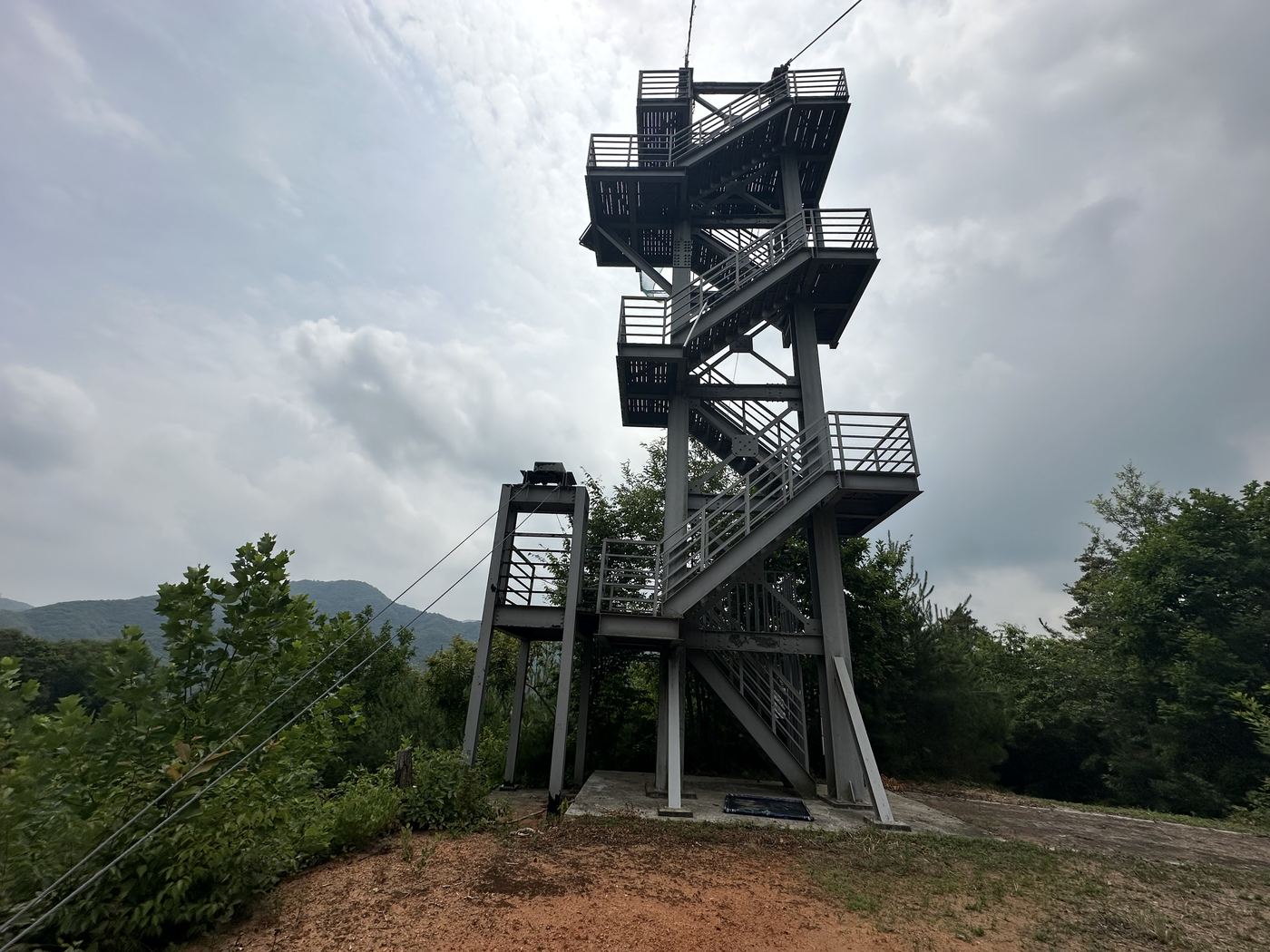
From a GPS coordinate alone, the drone finds the structure by itself, builds a 3D mesh, and acquires member-level inspection data through two-stage autonomous flight. Currently under way as commissioned research for NDMI.
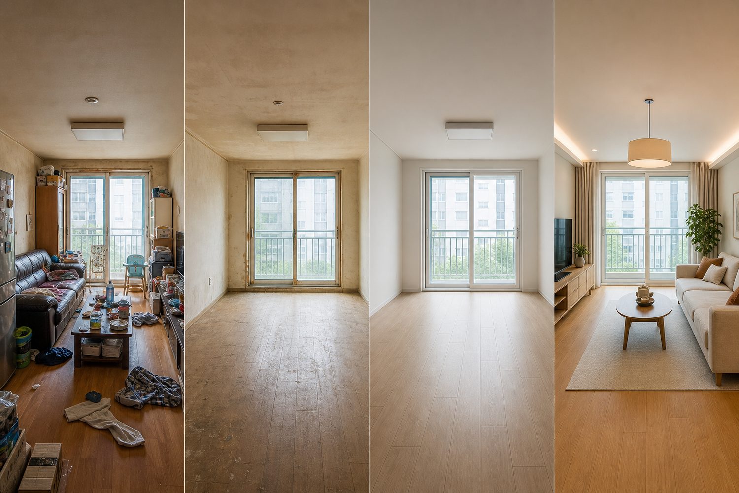
A single phone video reconstructs the home you live in as a 3D digital twin, erases the furniture, recovers the occluded space, and lets you simulate a new interior on top of your actual home.

One photo of your living room is enough. Décor only, furniture too, finishes too, or a full remodel — you decide how far it changes, and everything outside that scope stays exactly as it is.
Technology that works in the field
For inspectors, the location to check first and the evidence for it. For managers, a comparable history and a report. Turning technology into the language of the field is GIPTER's design principle.
It starts from a GPS coordinate alone. With no prior drawings or BIM, it reads the site's geometry in real time and begins inspecting autonomously.
Wide-area 3D mapping, then member-level close approach — two stages that secure the most inspection data in the fewest flights.
GNSS/RTK + LiDAR-inertial odometry (LIO) + UWB correction keep flight safe even where GNSS is blocked.
Optical (RGB), thermal (IR) and LiDAR are combined according to structural material and conditions, suppressing the false detections a single sensor produces.
Projects
The technology GIPTER is working on right now, and where it is headed. Field validations and PoCs in progress are shared separately after discussion.
Suspension footbridges, ziplines, bungee jump towers — structures people once had to hang from to check are now watched by a drone instead. We are developing two-stage autonomous flight that reads a structure's shape from a single coordinate, triple-redundant navigation that holds position where GNSS drops out, and multi-sensor AI detection that catches members as thin as a cable. Inspection results stay on a 3D map and are compared against the next inspection.
Carried out as commissioned research for the National Disaster Management Research Institute, MOIS, through 2028.
Photogrammetry, remote sensing and computer vision are not fields one company carries alone. GIPTER validates its damage-detection models and training-data design on the same desk as university labs. Data from the field goes into research, and the models that come out of research go back to the field.
Joint research with the Industry–Academic Cooperation Foundations of Myongji University and Inha University.
Milestones
Yongin, Gyeonggi-do · Application software development and supply
Software business filing with the Korea AI Software Industry Association
“Development of a Commercial-Drone-Tailored Facility Safety Inspection Platform and Management Technology” · Consortium with Myongji University and Inha University · Responsible for the drone platform and SDK flight control (2026–2028)
Hyundai E&C, AI/AX track
Where gipter works
From inspecting structures at height and in hazardous zones, to the homes people spend every day in. The same 3D spatial technology solves very different problems.
Automates precise inspection of vulnerable members at height — pylons, cables, hangers, anchorages and connection joints — that people cannot easily reach.
Even for structures with no drawings or complex geometry, the system reads the 3D shape on site in real time and plans its own inspection path.
Reconstructs the home you live in exactly as it is, so remodeling, moving and sale decisions rest on spatial data rather than images.
Client


Research partners


Free web tools
No install, no sign-up — they run right in your browser. Your files never leave your device.
See all web tools →Let's talk
Facility inspection field validation, remodeling and interior pilots, material and furniture brand partnerships, joint R&D — collaboration in any form is welcome. This page is based on GIPTER's project documentation and product materials.
We use Google Analytics cookies to understand how our website is used. With your consent, they help us see which pages are read, as anonymous statistics. They are not used for advertising. Privacy Policy